- JP
- EN
Organizational Structure and Business Processess
Safety Operation Management System
The Safety Enhancement Committee, which is a subordinate organization of the Executive Committee, conducts deliberations and reviews on matters related to the safe operation of MOL Group-operated vessels, to ensure and reinforce safe operation across the Group.
The Chairperson of the Safety Enhancement Committee is the Chief Operating Officer(COO), while the Vice-Chairperson is the Chief Safety & Quality Officer (CSQO), who is responsible for overseeing the formulation and promotion of strategies to ensure and enhance safety and quality throughout the MOL Group. The Board of Directors assumes supervisory responsibility for initiatives related to safe operation.
The Headquarters of Safety Operations is responsible for planning and executing Group-wide safety initiatives and provides guidance to each business headquarters and MOL Group company on the implementation of safety measures.

Safety Operation Supporting Center
History and Role of the Safety Operation Support Center
In 2006, MOL experienced four major maritime accidents on the vessels we operate. After the accidents, we conducted a thorough investigation into the causes, and in February 2007 we established the Safety Operation Supporting Center (SOSC) with the motto "Never leave the captain alone". The SOSC operates 24/7 onshore, supporting our vessels as a help desk.
Since its establishment, our on-duty staff, including experienced captains, have been providing safety operation support 24/7.
In recent years, risks related to vessel operation have increased due to unexpected severe weather and oceanic conditions, geopolitical risks due to international tensions and conflicts, and more. In order to appropriately manage these factors, close communication between on-shore and the vessel is becoming evermore crucial.
Taking to heart the lessons from past accidents, we are fully committed to preventing major accidents from happening again and aim to achieve "the world's highest level of safe operation".
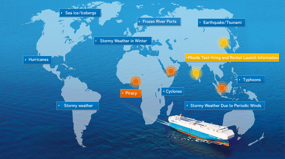
- Sea Ice /Icebergs
- (Surrounding Newfoundland/Sea of Okhotsk)
The SPIRIT system uses color-coding to designate the number of icebergs in an icy sea area. Areas with the greatest number are displayed in dark red. Iceberg warning areas (the area surrounded by a light blue line in the image below) is set based on latest iceberg information gained from our contract weather company twice a day throughout a year, to alert our vessels to avoid these waters. In addition, iceberg warning areas are automatically set in the system from December through March every year, and SOSC provides that information, alerting our operated vessels.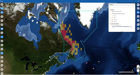
Red indicates areas where sea ice and icebergs have been observed.
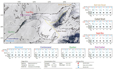
- Frozen River Ports
- From December through March of every year, we obtain freezing information of river ports such as the Great Lakes and Baltic Sea from our contract weather company. SPIRIT sets iceberg alert areas in river ports at risk of freezing. SOSC provides that information, alerting concerned vessels and parties on land.
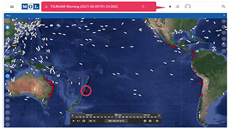
- Earthquake/Tsunami
- When an earthquake with an intensity of 6.5 or more occurs, SOSC confirms the safety of all vessels anchored in areas considered at risk by phone and email. In case a tsunami is detected, SPIRIT displays ports that may be affected, and vessels positioned within 200 miles of those ports, in flashing red. In addition, tsunami information is distributed to all our operated vessels at once.
- Stormy Weather in Winter
- In both the Northern and Southern hemispheres, stormy weather areas can occur due to low pressure systems developing during the winter, and the seas get rough. SPIRIT displays areas with high waves in red, and updates areas to watch for every 24 hours. Vessels that may enter these areas (orange) are displayed in orange, and the latest information on stormy weather is automatically distributed to concerned vessels. SOSC checks and monitors the movement of vessels at risk of encountering stormy weather.
- Missile Test-firing and Rocket Launch Information
- We have a system to receive preliminary reports by email when a missile is test-fired. SOSC promptly confirms the safety of concerned vessels by phone and email. Trajectories of missiles are designated in the system based on the past missile landing information. In case we acquire firing information ahead of time, we provide that information and alert our operated vessels.
In addition, when we acquired information regarding a rocket launching, SOSC sets the target area in SPIRIT (partially set automatically), alerting vessels in the area and concerned parties on land.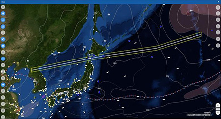
- Typhoons
- (Northwest Pacific Ocean)
The names of tropical storms change depending on the area where they occur and the force of their winds. Storms occurring in the Northwest Pacific Ocean (north of the Equator and west from 180 degrees east longitude) with maximum wind speeds of 34 knots or more, are called typhoons. Using SPIRIT, we can check the latest typhoon information and predictive models in each country every three hours. Vessels that may be affected by typhoons are displayed in red, and typhoon information is automatically distributed to concerned vessels every six hours.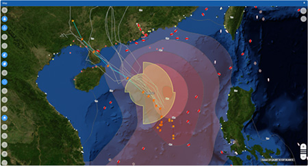
- Cyclones
- (Indian Ocean/South Pacific Ocean)
The names of tropical storms change depending on the area where they occur and the force of their winds. Storms occurring in the Northern Indian Ocean, Southern Indian Ocean, and Southern Pacific Ocean, with maximum wind speeds of 34 knots or more, are called cyclones. Using SPIRIT, we can check the latest cyclone information and predictive models in each country every three hours. Vessels that may be affected by cyclones are displayed in red, and cyclone information is automatically distributed to concerned vessels every six hours.
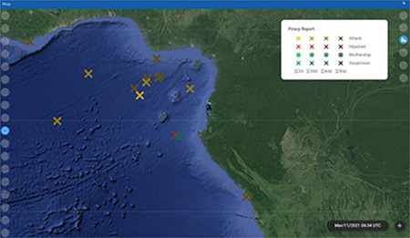
- Piracy
- We increase our surveillance of piracy in sea area where incidents of piracy occur frequently, such as the Gulf of Aden and the Gulf of Guinea. In addition to real-time AIS positioning information of vessels entering these sea areas, we have built a system that automatically detect the position of vessels using the Inmarsat satellite every hour as a backup function. SOSC designates areas at risk of piracy based on reports from our marine consulting company and information from various websites that track pirate activity, which we monitor daily. SOSC also provides that information, alerting our operated vessels within a 100-mile radius of any incident, within 48 hours of its occurrence.
- Stormy Weather Due to Periodic Winds
- (Indian Ocean/South China Ocean)
Winds that blow in a definite direction in a specific season and specific region are called periodic winds. In the summer, these winds blow from sea to continents, in the winter, from continents to sea. In the Arabian Sea, the southwest periodic wind (monsoon) occurs from June through September, and in the South China Sea, the northeast periodic wind prevails from October through May. In case stormy weather is forecasted, SOSC increases surveillance of vessels underway near the area to alert them.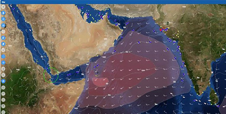
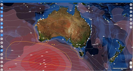
- Stormy weather
- (All sea areas)
Stormy weather occurs in all sea areas, regardless of the season as low pressure areas develop. Sea areas with high waves are displayed in dark red in SPIRIT. Areas to watch out for are automatically updated every 24 hours in the system, and vessels that may enter the orange frames (alert areas) are displayed in orange during the target period. In addition, the latest weather information is emailed to concerned vessels. SOSC also checks and monitors the movement of vessels at risk of entering the alert areas.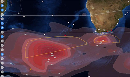
Red boxes indicate areas where stormy weather is expected, and red boxes indicate ships that are expected to encounter stormy weather.
- Hurricanes
- (Northeast Pacific Ocean/Atlantic Ocean)
The names of tropical storms vary depending on the area where they occur and the force of their winds. Storms occurring in the North Atlantic Ocean, Caribbean Sea, Gulf of Mexico, and Eastern North Pacific Ocean (east from 180 degrees west longitude) with maximum wind speeds of 64 knots or more, are called hurricanes. We can check the latest hurricane information and predictive models in each country every three hours using SPIRIT. Vessels that may be affected by hurricanes are displayed in red, and updated hurricane information is automatically distributed to concerned vessels every six hours.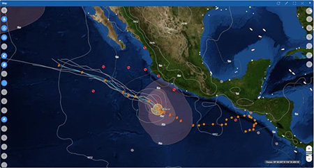
- Sustainability TOP
- Message from the Chief Sustainability Officer
- Sustainability
Management - Value Creation
Stories - Safety & Value
- Environment
- Human & Community
- Innovation
- Governance
- Stakeholder
Engagement - Sustainable Finance
- Sustainability Data
- ESG Disclosure
Guideline Indexes - External Recognition
- Library